Watershed Protection
Counting the trees in – and outside of – the forest: A best estimate of forest cover in the Delaware River Basin
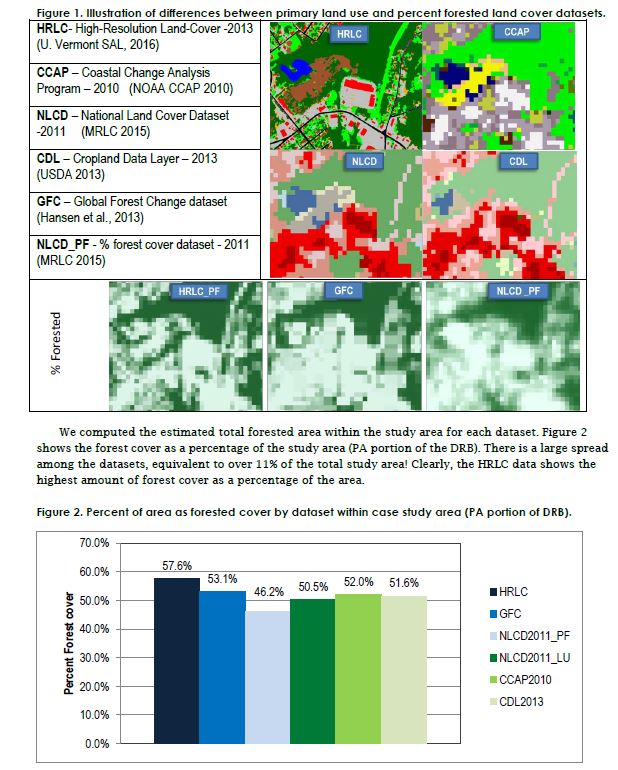
Forests play an important role in the health of watersheds by regulating hydrology (through canopy interception, infiltration, transpiration), soil quality, temperature, and pollutant uptake. Clearing or degradation of forests can be directly linked to water quality changes. But tracking loss of forest is not necessarily straightforward, and there is no single, authoritative data source for forest cover.
Typically, forest area is estimated based on some type of land use or land cover data, which is generally derived from processing of satellite or other aerial imagery. These datasets represent continuous coverages of the land (and water surface) and are broken down into pixels, most commonly at 30-meter resolution. Land use datasets assign a value to each pixel representing the land use type (such as forest, developed areas, or agriculture).1 Land cover datasets instead assign values that describe literally what is covering the land surface such as tree canopy, low vegetation, pavement, buildings, etc. For example, certain land cover datasets assign a ‘percent forested’ value to each pixel to represent how much of each pixel an algorithm determines is under tree canopy. Both types of data have their drawbacks when estimating forest cover.
Published: December 2016
Download Report